Collecting field data to measure plants from space
Climbing towers in Finland, the Netherlands, and recently in Ghana, PhD candidate Amie Corbin is crossing borders to collect essential data on vegetation for the MULTIPLY platform. For her research at the Institute of Environmental Sciences at Leiden University, she studies the ecologically important plant traits that can be measured from space.
In order to model data and create earth observation products with the MULTIPLY platform, prior knowledge on the vegetational variables is needed. Corbin collects this knowledge. “I focus on variables that can be both physically observed from space and are ecologically relevant. These variables can be indicators for vegetation health, like chlorophyll and leaf water content.”
Most measurements of plant traits that are currently available are from the peak moment of its growing season. Corbin tries to fill in the knowledge gaps. “By measuring traits of plants at different moments of the year I try to get a grip on year-round phenology,” Corbin explains. “This gives us a better understanding of whether some characteristics are trade-offs or if they are consistent throughout the year.”
Challenges in the field
Corbin collects measurements from three different types of vegetation: mixed forest in Finland, coniferous forest in the Netherlands and tropical forest in Ghana. “We try to discover how different characteristics from plants are related to each other and how this relationship changes over time, at different latitudes.”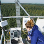
Using a field spectrometer, Corbin measures the reflectance of light. This is similar to how satellites measure reflected radiation from space. But the field measurements result in a higher resolution. “To measure the reflectance, one sensor was placed at the top and one at the bottom. The more plants there are, the less of the light that can be used for photosynthesis will make it to the ground level. Based on this difference we can measure the Leaf Area Index, the amount of leaf area,” Corbin explains.
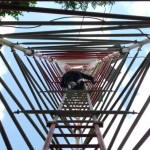
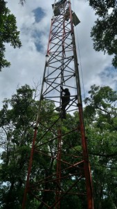 Collecting the measurements and samples was challenging. “The observation tower that we had to climb to take the samples and collect measurements was quite high, around 30 meters. I was a bit scared to climb the tower and enter the platform at the top, which was quite small,” Corbin admits. Fortunately, she was accompanied by a local guide and an expert tree climber who helped her out. “Our hosts in Ghana from the Forestry Research Institute of Ghana were great.”
The fieldwork was done every two weeks at the same location. “Because the sampling is destructive, and two weeks is enough to let the plants live,” Corbin explains. “Also, it is a lot of samples to process each time.”
Convenient collaborations
A big challenge Corbin encounters during her research is the clouds. Because clouds influence her imagery. “As a person who does not like the heat I am glad when a cloud shows up but as a scientist I really need them to be gone,” says Corbin. Fortunately for her, there are other researchers in the MULTIPLY team who atmospherically correct the images.
Corbin is enthusiastic about the collaborations within the MULTIPLY project and the platform that is being built. “I like that we collaborate not only with other universities but also with big companies. This is really helpful in creating an easy to use platform for remote sensing imagery.”